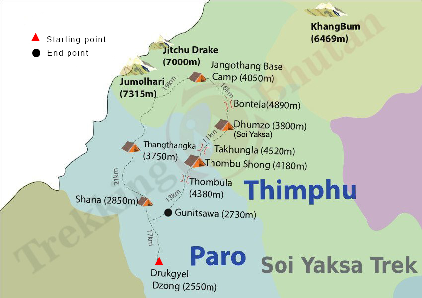
Soi yaksa trek
or call +975 77845366
The highlight of Soi yaksa trek is the spectacular view of Mount Jumolhari from the base camp.
This trek is also known by different names such as Jumolhari Trek II, Yaksa Trek or simply the Jumolhari Loop. If you simply have a desire to sight Mount Jumolhari and Jichu Drake without slogging up to Lingzhi and high altitude, Soi Yaksa Trek is right for you. However this trek still goes up to an elevation that could bring you altitude sickness. You can retrace you steps back from Jangothang base camp, crossing the turquoise Tshophu lake (4380m) and Bhonte La pass (4890m) to Drukgyal Dzong. And from the Thombu La pass (4380m) on second last day, beautiful white mountain range of Kanchenjunga in Sikkim is just rewarding
HIGHEST ALTITUDE
- 4890m
AVG. WALKING DISTANCE
- 16Km
AVG. WALKING TIME
- 6 Hours Average
MEALS ON TREK
- Breakfast, Lunch, Dinner & Snacks
Includes & Excludes
What's included
- Government levy/taxes & visa fee
- Transport by private vehicle
- Government approved 3-star hotels
- English speaking guide
- Bottled water in vehicle
- Permits, entrance fees, & sightseeing
- Sleeping tents, sleeping mats & pillows
- Dinning tents, kitchen tent & toilet tent
- Tables, chairs, utensils, hot water bags
- Trekking chef & assistants
- Horses to carry trek equipments
- Food supplies
What's not included
- Airfare
- Insurance
- Laundry
- Drinks & beverages
- Phone/internet bills
- Tips
- Wire transfer charge/card fee
- Sleeping bag
- Other bills of personal nature
Trek Route
15KM | 5-6 HOURS | 230M ASCENT | 60M DESCENT | CAMP ALT 2870M
You will drive 12km north of Paro valley from your hotel to the historic Drugyel Dzong ruins at 2580m, from were your trek starts. Your trekking crew will be waiting here for you. After a brief meeting, you will walk downhill on a wide trail following the Pachhu (river), which then climbs gently traversing through well-maintained rice terraces and fields of millet. Soon the valley widens and the route enters an area of apple orchards, traditional farmhouses and the tiny settlements of Mitshi Zampa and Sangatan. You reach the army post of Gunitsawa at 2810 after walking for a while through blue pine forest. Here your trekking permit will be checked and stamped. This is the last stop before Tibet and border close to it. You will then cross Pachu River on a wooden bridge and then climb to Sharna Zampa at 2870m. Just beyond Sharna Zampa, there are several meadows surrounded by trees where you will camp for tonight.
20KM | 8-9 HOURS | 900M ASCENT | CAMP ALT 3750M
The trail again follows Pa chhu (Paro river), ascending and descending through pine, oak and spruce forests. After 2 hours of continuous hiking and crossing several streams, you will reach at Shingkharap, a stone house at 3110m. A hot lunch will be served after crossing the bridge towards the left side of the river. Little ahead is the trail junction – left an old trade route and invasion from Tibet and right leading to the wooden bridge (we follow the right). After climbing up through rhododendron forests and finally crossing the bridge again, we reach our camp at 3750m, which is amidst beautiful meadows.
17KM | 4-5 HOURS | 290M ASCENT | CAMP ALT 4040M
Although today’s is not a long trekking day, a significant height gain will take place as your trail goes above tree line. From the camp, your path ascends for a while till you reach the army camp. Then follow the river above the tree line enjoying the stunning view of surrounding peaks. We walk through a very muddy section of trail, pass a mani wall and enter yak country. Hot lunch will be served inside a yak herder’s camp. After lunch, we walk past yak herder settlements of Soe and Takethang. Common crops that people grow here are barley, potatoes and turnips. We walk our final approach across a plateau and up a stream bed and Dangochang village to the awesome campsite of Jangothang at an altitude of 4040m. From here, the views of Mount Jumolhari and Jichu Drake are superb.
Today, you will spend a day by doing four-hour acclimatization hike to the north of your camp. There is practically no trail but you will climb on a open and endless slope till you see the view of Mt Jichu Drakye (6989m). You can scramble further up till 4895m (higher than Mount Blanc) to see amazing view of Mount Jumolhari. You are likely to spot rare blue sheep, Himalayan rhubarb, griffon vultures, golden eagles and the remarkable blue poppy. Jangothang base is a flat grassy land with an old ruined fortress on a hillock in the foreground, beneath the colossal Mount Jumolhari and its neighbour Jitchu Drake. Most people show signs of mountain sickness at this altitude and it is recommended that all trekkers halt here. If you do not wish to hike but simply wish to just relax in camp, whichever option you choose, its certainly going to be a memorable day.
16KM | 6-7 HOURS | 810M ASCENT | 1090M DESCENT | CAMP ALT 3800M
The trail leads north to the last settlement in the valley and descends once again to the Paro Chhu (River), crossing it on a wooden bridge. Walk up to the turquoise Tshophu lake (4380 meters), which is inhabited by ruddy shelducks. You will come across a second lake after you climb across a slope to a crest. Then descend into a hidden valley and climb steeply to Bonte La at 4890m, the highest point of the trek with great mountain views of Basingthang (5500m) and Chatarake (5570m). After the pass, the trail descends crisscrossing yak trails down to the Dhumzo Chhu and after walking downstream past few houses you arrive at a camp at 3800 meters.
11KM | 4-5 HOURS | 720M ASCENT | 340M DESCENT | CAMP ALT 4180M
The trail climbs over 100m over a ridge, and then drops to another stream. Crossing that stream, the trail heads up the hillside, dropping into a small side valley before emerging onto a ridge. Here the route turns south, ascending past few huts to Takhung La (4520 m). A short descend leads to wide and grassy Thombu Shong (4180m) with few yak herder’s huts.
13KM | 4-5 HOURS | 200M ASCENT | 1650M DESCENT | CAMP ALT 2730M
Climb out of the valley through rhododendron forests to Thombu La at 4380m. On clear weather, great views of Mount Jumolhari, Jichu Drake, Teri Kang and even Kanchenjunga from the pass is rewarding and a treat for the hectic minds. Trail then drops gradually to about 4000m, switching back down the ridge, you finally reach the helipad at Gunitsawa (2730m). Your vehicle will be waiting here to pick you up. Drive to Thimphu where you can celebrate your return to civilization with a refreshing shower in the hotel. Overnight at a hotel in Thimphu.
Dates & Itinerary Don’t Fit?
We can create a custom-made itinerary for you. Choose your date of travel, what would you like to see and where would you like to go.
- Email us at: @trekking-in-bhutan.com
- Call us at: +975 (M) 77845366
Similar Treks

The alpine quest, which is billed as the world's most difficult trek runs along the Northern border crossing highest pass of 5320 meters.

Trek to this twin villages offer great opportunity to experience unique lifestyle of semi-nomadic yak herders in extreme north east of Bhutan.

The trek is aptly been named as the Beautiful Laya Gasa Trek. The highlights of the trek includes: snow-capped peaks, yak herders, flora & fauna and landscapes.

Dagala Trek offers one of the most enchanting view of valleys of Thimphu and Lower districts in south. Great opportunity to see high altitude lakes and yak pastures.